Down The MacKenzie to The Arctic with The Governor General
The following article was published in January 1926.[1]
Down The MacKenzie to The Arctic with The Governor General
By Major W. Arthur Steel, M.C., The R.C.C.S.
With the establishment of a chain of posts from Edmonton to the Arctic, the Department of National Defence has become actively interested in the Mackenzie Basin. This fact alone is sufficient to command the attention of officers and members of the Department, but since our Governor General has paid a visit to this territory, we have now an added incentive for studying the local conditions and future possibilities of this little known region. It is for this reason that the writer has undertaken to describe briefly the outstanding features of the country, as observed during the trip with His Excellency from Waterways to Aklavik and return, during the past summer.
Before beginning the description of the country, it might be as well to get some conception of the extent of the area through which the Mackenzie River flows. It is true that figures alone mean little, yet most of us have travelled sufficiently to be able to appreciate comparative distances even if we cannot visualize the miles themselves. From Edmonton to Fort Smith, the most southerly settlement in the North-West Territories, is a distance of 603 miles by the shortest route via Fort McMurray and the Athabasca River. From Fort Smith to Aklavik, in the Mackenzie Delta, the end of the steamer trip, is a further 1,369 miles. The round trip from Edmonton to Aklavik and return is, therefore, 3,944 miles, or a little farther than from Halifax to Vancouver over the Canadian National Lines. A glance at the accompanying map will assist the reader to follow the party as it proceeded down the river.
There are two main routes whereby travellers from Edmonton can reach Fort Smith, the seat of Government for the District. The first, and the shortest one, is via the Alberta and Great Waterways Railway to Waterways, near the junction of the Clearwater and Athabasca Rivers. Then by river steamer down the Athabasca to Chipewyan on Lake Athabasca, and from there along the Slave River to Fort Fitzgerald. From Fitzgerald to Smith there is a portage of 16 miles around the so called “Rapids of the Drowned.”
The second route from Edmonton is by way of the Edmonton, Dunvegan and British Columbia Railway to Peace River Landing on the Peace River. From here a river steamer runs as far as Fort Vermillion, where another portage is necessary around the famous Vermillion Chutes. Another steamer completes the journey down the Peace to its junction with the Slave River not far below Chipewyan, and from this point on to Smith the trip is a duplication of the one outlined above. This second route was the one taken by Lord Byng, although it is not the normal method of reaching Fort Smith on account of the greater distance to be covered.
As explained in a previous article [The Work of The Royal Canadian Corps of Signals in the Field of Radio Communication in Canada, C.D.Q., Vol III, No. 1, October, 1925], the writer did not join the party until it reached Fort Smith, but in order to maintain the continuity of the story, the country will be described beginning with the writer’s trip from Waterways. This town was built about 1921 as the northern terminus of the A. and G.W. Railway. It is located on the left bank of the Clearwater River, about 8 miles above its junction with the Athabasca River at Fort McMurray. This is the point where both passengers and freight are transferred from rail to river boat. During the early part of the season the steamers can get up as far as Waterways, but from about August on everything has to be floated down to McMurray on barges and light draught gas boats.

|
McMurray is an old Hudson’s Bay post, prettily located at the foot of a high bluff on the right bank of the Athabasca River just above the mouth of the Clearwater. Until recently it was District Headquarters for the Hudson’s Bay Company but is now only a local office, the main office having been moved into Edmonton. The population at present is barely 500 people and the main industries of the district are salt and tar sands. These industries are both developing rapidly at the present time. The railway has not been extended into McMurray on account of the ice difficulties which exist on the low lying land in the early Spring.
Chipewyan is the next important settlement reached enroute. It is one of the oldest and most important of the fur-trading posts of the North and is located on the north shore of Lake Athabasca, near the western end of the lake. The entire north shore of the lake is composed of red granite, and is very beautiful indeed, with its many spruce covered rocky islands lying just off shore. It was from Fort Chipewyan that Alexander Mackenzie set out in the spring of 1789 on his historic voyage down the Mackenzie River to the “Frozen Ocean.”
The stretch of river between Chipewyan and the mouth of the Peace River is interesting in that its direction of flow depends entirely on the relative heights of the water in the Peace River and in Lake Athabasca. The banks here are low and marshy, and in the fall the huge mud flats form a sportsman’s paradise, with their multitudes of ducks and geese enroute South.
Ninety miles below Chipewyan we come to Fort Fitzgerald, the northern terminus for this first stage of the river transportation service. During the summer time it is very active, since every pound of freight destined for the Mackenzie Basin must be unloaded here and reshipped by team and tractor over the portage to the landing at Fort Smith. The trail on the whole is good. The roads are composed largely of sand, and have been so placed that the natural drainage maintains a fairly dry surface. The trip to Fort Smith occupies about one hour, and for this part of the journey the traveller will find available a wide variety of vehicles from the impertinent little Ford to the lordly Winton Six.
Fort Smith, with a population of about two hundred, is not only the seat of Government for the Northwest Territories, but it also the base of operations for all transportation on the Mackenzie. The town has a permanent and substantial appearance, the buildings are well made and the town nearly laid out. The Administration Buildings and Government House are handsome log structures located in the centre of the settlement. Upon entering the main office, the traveller finds a hearty welcome awaiting him from Mr. MacDougall, the District Agent, no matter whether you come to buy a trapping license or merely to pass the time of day. There is a well equipped hospital in Smith, run by the Grey Nuns of Montreal, but with Dr. A.L. McDonald of the Indian Department as the Medical Supervisor. And now that Fort Smith is in daily touch with civilization through the medium of the new Government radio station, it bids fair to be one of the coming business centres of Northern Canada.
There are two transportation companies operating in the Mackenzie Basin at the present time. These are the Alberta and Arctic Transportation Company and the Northern Trading Company. Both companies give a weekly passenger service from Waterways to Fitzgerald during the summer months but from Smith to Aklavik only three round trips are made by each concern in a season. This year the Northern Trading Company had bad luck with their boat and were only able to make one complete round trip. The Governor General travelled on the “S.S. Distributor” of the Alberta and Arctic fleet and the boat was specially fitted both for accommodation and communication.
On July 22nd the vice-regal party arrived in Fort Smith, having been delayed several days at Vermillion Chutes due to low water. The official party consisted of His Excellency the Governor General, with Major P.K. Hodgson, his Private Secretary; Inspector Fletcher of the Royal Canadian Mounted Police; Mr. O.S. Finnie, Director of the Northwest Territories Branch; Mr. John Melvin, the representative of the Hudson’s Bay Company, and the writer. In addition there were on board a number of Government officials, tourists and trappers going to Aklavik, or to intermediate points on the river.
From Smith to Great Slave Lake the country is not particularly interesting, although it is valuable on account of the lumber found in the area. The land is flat and swampy but contains much valuable spruce timber. The average size is given by the Government reports as about fifteen logs per thousand feet. There is one saw mill in this area at present, located at Grand Detour, about 40 miles below Fort Smith. Great Slave Lake is an immense body of water and offers the one real obstacle to transportation in the Mackenzie Basin. It is difficult to design a boat of shallow draft and large carrying capacity for use on the rivers, and still have a hull capable of standing the storms and rough weather frequently met with on these waters. As a result, steamers are frequently delayed for days waiting for suitable weather to cross the western end of the lake, and even then it is often necessary to run for shelter due to a sudden squall coming up.
Near the mouth of the north arm of Great Slave Lake there is an extensive gold-bearing quartz ledge. Work on this has not as yet progressed very far, due mainly to transportation difficulties, but the engineers claim that prospects are very good.
Fort Resolution is located on Great Slave Lake, just west of the delta at the mouth of the Slave River. It is an important settlement, with trading posts and a large Indian boarding school run by the Roman Catholic Mission. There are important lead-zinc ore deposits in this area upon which extensive development work has already been carried out. His Excellency disembarked at this point and visited both the School and the Hudson’s Bay Post. It was here that his health was proposed and drunk to by the Sisters in good fresh cow’s milk, considered quite a delicacy in the north country.
We reached Hay River Settlement on the south shore of the Lake about 1 a.m. on July 26th, after spending 24 hours at Burnt Island waiting for the wind to drop. This Island lies about half way between Resolution and Hay River and is a haven of refuge for all shallow draft vessels when the wind blows. Hay River is an Anglican Mission centre, particularly noted for its fine vegetable and flower gardens. There is a large Indian boarding school here also, run by Canon and Mrs. Vale, and late as it was Lord Byng made a thorough inspection of the Church and School. As we were leaving, Mrs. Vale presented the party with huge bouquets of flowers. The size and brilliant color of the blooms were quite remarkable as was the variety of flowers she has been able to grow. Her Sweet Peas were the finest the writer has seen anywhere.
Fort Providence, on the western end of Great Slave Lake, has the largest Roman Catholic boarding school in the territory. The Mission here has the most extensive garden under cultivation in the North, the yield of potatoes often running as high as 3,000 bushels, with other vegetables in smaller quantities. The children at Providence welcomed His Excellency, and after singing a song of welcome specially composed for the occasion, one of the Indian girls read an address in English.
Leaving Providence, the boat crossed Mills Lake and then entered the Mackenzie River proper. The river is narrow and very rapid with high gravel banks. The country is wooded but the timber is smaller and less valuable than on the Slave River. It is used solely for fuel for the settlements and for the river steamers.
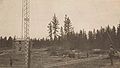
Fort Simpson is not only a trading post but is also the central station and relay point for the Northwest Territories Radio System. It is 150 miles from Providence and lies on an island at the mouth of the Liard River. For this reason it is an important transfer point for freight and fur to and from the North Liard District. There is a hospital here, operated by the Sisters of the Catholic Mission, but at present there is no doctor on the station. The Indian Department and the R.C.M.P. both have posts here, the Police Inspector for the Simpson-Good Hope District being located at Simpson. One of the illustrations shows a view of the Mission potato field. His Excellency spent several hours ashore inspecting the places of interest, including the radio station. This was the first point at which he inspected a military detachment and he was good enough to compliment Lieutenant Galbraith on the appearance of both the men and the station.
The next 450 miles is perhaps the finest of the whole trip, from a scenic point of view. After leaving Simpson the scenery changes completely. The low rolling country gradually disappears and ranges of mountains, with well marked peaks, make their appearance on both banks of the river. Wrigley, the next settlement on the river, is a small post on the west bank, but immediately opposite there is a peculiar rocky formation known as “Roche-qui-trempe a l’eau,” rising to a height of 1,200 feet above the water. It is peculiar in that the stratification of the rock is practically vertical, and it is one of two points where the mountain formation comes out to the river. The other is at Fort Norman.
After leaving Wrigley, forest fires were encountered and for a hundred miles nothing whatever could be seen of the surrounding country. During the night of July 28th we had one of the worst electrical storms any of the party on the boat had ever witnessed. The lightning was practically continuous and so vivid that the Pilot could not see the course and we were forced to tie up to the bank for several hours. The terrific rain which accompanied the lightning was instrumental in putting out most of the forest fires, however, and next day we could see quite distinctly. On the return trip the smoke had almost entirely disappeared, although there were a couple of bad fires still burning some distance back from the river, and perhaps 50 miles north of Wrigley. This clearer weather enabled us to discover that the mountains which had skirted the river as we approached Wrigley receded again between Wrigley and Norman. However, they were always in sight and formed a strong background for the scenery. The banks of the Mackenzie along this stretch are, in places, very high, rising from 100 to 400 feet above the water.
Major Burwash in his report states that the territory lying between the Mackenzie and the eastern boundary of the Yukon is not likely to prove valuable from a mining standpoint. However, in 1921 and ’22 some valuable placer claims were discovered on the Nahanni Rivers and even as far north as the Gravel. This area might develop in time, as it is fed from the same watershed that supplied the Stewart and Klondike Rivers in the Yukon. Up to date it has not been extensively prospected.
We reached Norman about noon and as we came down the river we saw on the right bank, just a few miles above the town, the outcroppings of coal which have been burning underground continuously since Alexander Mackenzie’s first trip in 1789. Smoke is still issuing from points along the bank but the fires are not as spectacular as they were a few years ago. Norman is a clean looking town built on a high ridge on the right bank of the Mackenzie, just south of the mouth of the Great Bear River. The famous Great Bear Rock, rising to a height of 1,300 feet, forms the north bank of the Great Bear River and extends back from the mouth for a distance of about six miles. It forms a very impressive background for the town itself.
The waters of the Great Bear River are of a beautiful clear emerald green color, and as the current is very swift, a sharply marked line of demarcation is found where the incoming stream cuts across the muddy Mackenzie. This line extends almost a third of the way across the Mackenzie at this point and can be followed for a distance of about 10 miles down stream.
At Norman His Excellency went ashore and visited the Trading Posts, the Police Barracks and the Mission. The Anglican Mission is closed at present but the Roman Catholic Mission is quite active. The church has been wonderfully decorated inside by one of the priests, and while the colours have been chosen to please the Indian more than the white man, the drawing and arrangements are very well done.
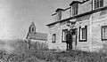
The ridge on which Norman is built is composed of two terraces, the lower one being occupied now mainly by the Indian population. One of the photographs shows the old Anglican Mission and some of the buildings in this part of the town.
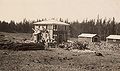
Fort Norman is best known for its Oil Wells. The country on both sides of the Mackenzie for a distance of 100 miles below the town is held under lease for petroleum and natural gas. Discovery Well, owned by the Imperial Oil Company, is located 60 miles below Norman, and is the only location at present active. The original well is capped and used to supply the “topping” plant operated by the Oil Company to furnish gasoline and fuel oil for their camp. It was “blown off” by Mr. Sutherland as a demonstration for the Governor General. Major Burwash in his report on mining developments in the Mackenzie Basin states that the output of this well reached sixty barrels per day shortly after completion, but it is not known whether this is being maintained at present. A new well was drilled during the past summer about 200 yards from Discovery, and had reached a depth of over 1,300 feet at the time of our visit. It is understood that negotiations are underway with the Hudson’s Bay Company to have them convert all of their river steamers to oil burners, the fuel to be supplied from the Norman Wells. The photograph shows the location of both Discovery Well and the new well referred to above.
Two other points of interest are passed before reaching Fort Good Hope, 170 miles below Norman. These are the Sans Sous Rapids and the Ramparts. The rapids are formed by a rocky ledge projecting from the right bank of the river and reaching almost to the opposite shore. Trouble is often experienced here at low water, especially when working up stream. On our return trip we seemed to be glued to one spot, and even with our powerful stern wheeler, we were hours navigating this short stretch of river. Between the Rapids and Good Hope the river is very wide and full of islands and sand bars, but about 9 miles from Good Hope it suddenly narrows and flows between two vertical limestone cliffs. This is the finest part of the trip from a scenic point of view. These cliffs are not unlike the chalk cliffs of Dover and they rise in places to a height of 250 feet.
Fort Good Hope, as will be observed from the photograph, is a very neat and attractive village. The houses are all white-washed and the town boasts a sidewalk along its main street. It is an important fur post but has no mining activities. The Catholic Church at this point is similar to the one visited at Fort Norman, and it is understood was decorated by the same priest, the arrangement and coloring being similar. We saw several potato patches at Good Hope that seemed to be doing well. The inhabitants informed us that their crops were fair on the average, but that this was as far north as it was possible to grow vegetables with any certainty of success. Father Robin, the priest at Good Hope, runs a Black Fox and Marten farm and has been very successful up to date.
A few miles below Good Hope we crossed the Arctic Circle, but as the spot is not specially marked there was some argument about the exact location of the line. The country here is generally flat and uninteresting, although we did pass through further chalk cliffs, known as the Lower Ramparts, just before reaching Arctic Red River.
Separation Point, thirty miles below Arctic Red River, marks the beginning of the Mackenzie Delta. This point was so named by Sir John Franklin because the party, of which he was the head, divided at this point for their further journeyings north.
From here, we doubled back for a short distance up the Peel River to visit Fort McPherson. This post is not so important now as it was in the old days, when the Dawson-McPherson patrol was the yearly adventure. While the boat was unloading freight, the party visited the town. His Excellency met Mr. John Firth, who for 52 years was Hudson’s Bay Factor at McPherson, but who has now retired “to give the younger generation a chance” as he says. The graves of Inspector Fitzgerald and his comrades, who were lost in the snow on the Dawson trail in 1911, were also visited. The Anglican Church maintains a large mission and day school at McPherson, and while the remainder of the party explored the town, the writer assisted Mr. Deacon, the Missionary, to assemble a radio receiver set which some well-meaning friend had sent him in a completely dismantled condition. We landed at McPherson at 11:30 p.m., and while our trip was too late in the season for the midnight sun, it was so bright that the town lighting plant did not have to be put into operation for His Excellency’s visit.
From Separation Point north the river broadens out into the delta proper. Numerous channels criss-cross the area but only two are used for navigation. The West Channel, or Aklavik River, is the more generally travelled route, but the eastern channel is the direct route to Kittigaruit and Richards Island. From Point Separation to Aklavik is a distance of 65 miles, but the entire delta area is roughly 100 miles long by 50 miles across, widening out somewhat as you go north. The soil in the delta is all alluvial deposit and the channels and bars are constantly changing position due to the action of the current. Some very remarkable examples of erosion are to be found along the channels of the Mackenzie Delta. Spruce trees ranging from 6 inches to 12 inches at the butt are found in the delta, and on one of the western channels known as the Husky River, there are some excellent stands of timber. From Aklavik north the vegetation rapidly deteriorates, however.
The Settlement of Aklavik is fast becoming the most important post in the Arctic. It is now the northern terminus of the river transportation companies, and in addition is the distribution point for the Hudson’s Bay Company for the posts in the Western Arctic and also for the more westerly points in the Eastern Arctic. The Anglican Church has had a mission here for thirty years, and this year, through the generosity of Colonel Leonard of St. Catherines, they have been able to erect a fine hospital and boarding school. The Indian Department is supplying the medical equipment and supplies and have also sent in a doctor to supervise the work. The Roman Catholic Church are just getting established in the delta, and during the past summer have also erected a hospital and native school at Aklavik. Several Sisters from the Mission at Resolution have gone down to Aklavik to supervise the work. Mrs. Cook, the wife of the Indian Department doctor, is a trained nurse, and it is felt that these two will be able to do a very valuable work in the development of this Arctic settlement. There is a large Police detachment at Aklavik, although the Inspector in charge of the district is still located at Herschel Island. Aklavik has witnessed a great building boom this summer, and as a result the transportation companies have had the biggest season in their experience. Not only have two hospitals and schools been erected, but the complete Government radio station with its towers and buildings has gone up, together with new warehouses and stores for both the Hudson’s Bay and the Northern Trading Companies.
The land at Aklavik is flat and covered with scrub trees and bushes. It is very wet back from the water front but draining operations are under way and would appear to be quite successful. Investigations made during the erection of the radio station showed that permanent frost is to be found during the summer at depths varying from eighteen inches up to eight inches, depending upon the distance back of the water. The writer did not observe evidence of any attempts at cultivation as yet, and it is doubtful if any such attempts would be very successful, in view of what has just been said about the soil. The summer is short but very hot, and during the few days we spent at Aklavik the weather was as warm as one would expect to find in Ontario during July or August.
We reached Aklavik 7:45 p.m. on July 31st, and as is usual in that northern country, the entire population was on hand to welcome us. His Excellency visited all of the points of interest mentioned but was disappointed when he found that he was too late to meet the Eskimos, the latter having left after the arrival of the first boat in June, for the scene of their summer activities along the Arctic Ocean. Canon Hester, the head of the Anglican Mission, suggested that a trip be made by motor-boat to Kittigaruit on the Arctic where he was certain they would find the Eskimos in their summer home. Arrangements were put underway at once for the trip. The Northern Trading Company provided the gas boat, “Miss Norman,” the Royal Canadian Corps of Signals loaned Sergeant Riddell as Engineer, and Canon Hester and Oliver, an Eskimo, accompanied the party as interpreter and pilot respectively. The trip was tiresome but otherwise uneventful, with the exception that they ran into heavy fog in the Arctic and were forced to depend upon Oliver’s sharp ears to guide them to the village. He navigated along the coast for the last 30 miles by the sound of the waves lapping on the beach. The boat reached Killigaruit at 7 a.m. on the 2nd, and as soon as the Chief was informed of the identity of his distinguished guest, he quickly organized a reception breakfast at which all the usual Eskimo dainties were provided. After the meal the Chief gave an address which was replied to by His Excellency, Canon Hester acting as official interpreter. This was the first instance in which a representative of the King had ever visited these northern people, and it will undoubtedly be long remembered by those fortunate enough to be present. The ceremonies over, the Chief presented Lord Byng with some valuable curios, after which the party left on the return trip to Aklavik. They arrived back at 6 a.m. on August 3rd satisfied but very tired, as a 24 foot boat does not afford much space for exercise or relaxation for a party of eight men. The photograph shows one of the impromptu luncheons served during the round trip of over 300 miles by motor boat.
One rather amusing incident of our stay at Aklavik concerns the inspection of the R.C.C.S. detachment at the radio station. It will be remembered that the party, consisting of Lieutenant Young, Sergeant Pearson and Corporals Riddell and Kerr, left Ottawa in July, 1924, for Herschel Island, the point where it was originally intended to erect the radio station. Their equipment, personal effects and clothing were shipped from Vancouver via the ill-fated “Lady Kindersley,” and as she was lost in the ice while enroute, the party reached Herschel with nothing more than the clothing in which they stood. The Police and Hudson’s Bay Company very kindly supplied our men with suitable, but of course, non-military outfits, so that by July, 1925, their original military clothing was, to say the least, badly in need of repair. On account of the rush of building operations at Aklavik last summer, we were forced to send by the first steamer only the essential building materials and equipment. Clothing and other necessaries were, in fact, on board the steamer on which the Governor General was travelling. The writer, anticipating the conditions likely to be found, had spoken to His Excellency about the matter, but even with that warning it was hard to keep a straight face while inspecting a military detachment composed of one officer in a partly civilian, partly military uniform – a Sergeant in a uniform made up of what would fit him from the remnants of the three Other Ranks’ uniforms – and two perfectly good Corporals in full Eskimo attire, furs and all.
The “Distributor” left Aklavik homeward bound at 9:30 a.m. August 3rd and reached Smith at 1:45 a.m. on August 12th, with nothing more exciting to report than a run in with a wind storm on Great Slave Lake after leaving Hay River and being forced to tie up at Buffalo River for fourteen hours. The weather was warm and bright during the return journey and stops of short duration were made at all of the points touched on the northern trip with the exception of Fort McPherson.
His Excellency inspected the Radio Station and the R.C.C.S. detachment at Smith and witnessed the erection of the second steel mast. After playing a round of golf on the local links, he left for Fitzgerald where the “S.S. Athabasca River” was waiting to take him back to Fort McMurray.
The writer separated from the party at Fort Smith to supervise the removal of the radio equipment from the “S.S. Distributor,” and to complete arrangements for putting the Fort Smith Radio Station into commission. This station was opened to the public on September 5th, and on October 7th Aklavik came on the air as a link in the chain of radio-telegraph stations stretching from Edmonton to the Arctic and touching Dawson City and Mayo in the Yukon Territory.
In closing, the writer would like to call attention to a rather remarkable condition existing in this interesting country. It will be observed from what has been said that the country produces very few of the necessities of existence, and the only exportable product is the fur catch. We therefore have the condition of two large transportation companies working strenuously for the entire summer, taking in supplies to maintain an industry whose entire output comprises a few thousand pounds of fur, brought out each summer on the return trip of the first steamer down stream.
Related Photos
The following photos are not part of the published article but were taken on the trip described in the article.
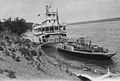
S.S. "Distributor" during the voyage of H.E. Baron Byng of Vimy down the Mackenzie River, N.W.T., 1925
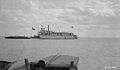
SS Distributor on the Mackenzie River 1925
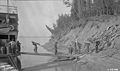
SS Distributor "wooding up" 1925
Leaving Fort Smith for the Lower River on July 22nd, 1925
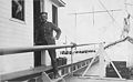
Sgt Lovelock aboard SS Distributor 1925
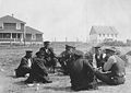
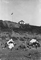
Tribe Chiefs at Fort Resolution NWT 25 July 1925
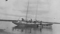
Ships on the Mackenzie River 1925
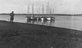
Schooners on the Mackenzie River 1925
RCMP at Post Office Fort Norman NWT 1925
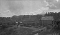
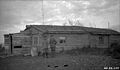
Fort Norman encampment and Hudson's Bay Co
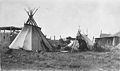
Indian camp at Fort Simpson NWT July 1925
Maj Steel and Lt Young at an Aklavik cabin August 1925
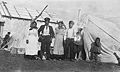
Eskimo family Aklavik NWT August 1925
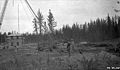
Fort Smith under construction 12 Aug 1925
Governor General Byng at Fort Smith Wireless Station 1925
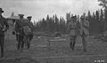
Governor General Byng at Fort Smith Wireless Station 1925
Fort Smith opening and flag raising

.jpg)


.jpg)
.jpg)

References
- ↑ Military Communications and Electronics Museum Archives.