Wrigley NWT and Y station
From RCSigs.ca
| Wrigley NWT and Y Station | |
|---|---|
| Northwest Territories | |
 | |
| Coordinates | |
| In use | 1944 - 1946 and 1948 - 1955 |
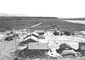
Wrigley station was originally established in 1942 to service the US Army's Construction Battalion on the Canol Project. That project was abandoned in 1944 and the station was turned over to the RC Sigs in November of that year. It was closed in 1946 but reopened again as an RC Sigs station in the spring of 1948 to provide weather information and to maintain the Canadian Pacific Airways landing strip. It was handed over to the Department of Transport on 3 May 1955.
Related Pages
- No related pages at this time
Related Items
Station Wrigley 1948
| ||||||||